
Freunden von diesem Artikel berichten:
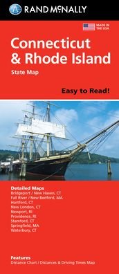
Rand McNally Easy to Read: Connecticut, Rhode Island State Map
Rand McNally
Bestellware

Rand McNally Easy to Read: Connecticut, Rhode Island State Map
Rand McNally
Rand McNally's Easy To Read State Folded Map is a must-have for anyone traveling in and around Connecticut and Rhode Island, offering unbeatable accuracy and reliability at a great price. Our trusted cartography shows all Interstate, U. S., state, and county highways, along with clearly indicated parks, points of interest, airports, county boundaries, and streets. The easy-to-use legend and detailed index make for quick and easy location of destinations. You'll see why Rand McNally folded maps have been the trusted standard for years. -Regularly updated, full-color maps. -77% larger map with a bigger type size than the Rand McNally Folded Map. -Clearly labeled Interstate, U. S., state, and county highways. -Indications of parks, points of interest, airports, county boundaries, and more. - Mileage and driving times map. -Detailed index. -Convenient folded size. Coverage Area Detailed maps of: Bridgeport/New Haven, CT; Fall River, MA; Hartford, CT; New London, CT; Newport, RI; Providence, RI; Stamford, CT; Springfield, MA; Waterbury, CT. Product Details: Dimensions (unfolded): 28 x 40.
| Medien | Bücher Landkarten (Land- oder Seekarten) |
| Erscheinungsdatum | 11. Oktober 2021 |
| ISBN13 | 9780528025679 |
| Verlag | Rand McNally |
| Maße | 102 × 226 × 15 mm · 113 g |
| Sprache | Englisch |
Weitere Titel von Rand McNally


Andere haben auch gekauft
![Cover for Preben Hansen · Turen Går Til: Turen går til Californien & Vestlige USA (Taschenbuch) [5. Ausgabe] (2021)](https://imusic.b-cdn.net/images/item/original/578/9788740063578.jpg?preben-hansen-2021-turen-gaar-til-turen-gaar-til-californien-vestlige-usa-taschenbuch&class=scaled&v=1623395637)
![Cover for Knud Romer · Den som blinker er bange for døden (Taschenbuch) [5. Ausgabe] (2016)](https://imusic.b-cdn.net/images/item/original/573/9788711569573.jpg?knud-romer-2016-den-som-blinker-er-bange-for-doeden-taschenbuch&class=scaled&v=1480182943)
![Cover for Kerstin Ekman · Ulvespring (Gebundesens Buch) [1. Ausgabe] (2022)](https://imusic.b-cdn.net/images/item/original/272/9788702347272.jpg?kerstin-ekman-2022-ulvespring-gebundesens-buch&class=scaled&v=1661970721)
![Cover for Jens Andersen · Kongeord (Gebundesens Buch) [1. Ausgabe] (2024)](https://imusic.b-cdn.net/images/item/original/776/9788740092776.jpg?jens-andersen-2024-kongeord-gebundesens-buch&class=scaled&v=1706260512)


Alle Titel von Rand McNally ansehen ( u. a. Taschenbuch , Landkarten , Gebundenes Buch , Buch und Spiralbuch )